Project 2 - Video Updates
ENV 761 - Landscape GIS | Spring 2025 | Instructors: Peter Cada & John Fay |
![]() These reflect the changes between the recording and the current (2025) running of the tools.
These reflect the changes between the recording and the current (2025) running of the tools.
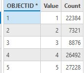
Task 2: Watershed Raster Attribute Table
Use this to check your watershed raster dataset.
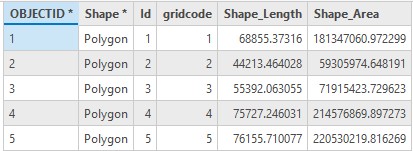
Task 2: Watershed Polygon Attribute Table
Use this to check your watershed polygon features (6:58 mark in video).
Task 6: Computing Floodplain
Use the flow distance tool here - but apply to the 15m DEM. And yes, you’ll have to create a new stream raster dataset with the 15m DEM (which is already filled), applying a 1000 flow accumulation threshold to identify stream pixels.